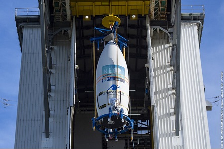
 Arianespace has launched the second high-resolution satellite in the new Airbus Defence and Space constellation on a Vega rocket, along with four rideshare cubesats.
Pléiades Neo 4, the second satellite of the Pléiades Neo Earth observation constellation, was launched by European launcher Vega from French Guiana last night. It was released from the launch vehicle, very close to its final 620-km sun-synchronous polar orbit, which it will reach within the next few days. The satellite will be phased 180° with Pléiades Neo 3 on the same orbit to start forming a constellation. This will enable daily imaging of any place on Earth at 30cm native resolution, and between two and four times a day when the four-satellite constellation is complete.
François Lombard, Head of Intelligence at Airbus Defence and Space, said: “Pléiades Neo will offer a truly best-in-class capability to our customers and will strongly enhance our position in the very high-resolution market. The first images from Pléiades Neo 3 are outstanding and confirm that we took the right decision in terms of design and performance to address the increasingly demanding requirements of the geospatial sector.”
Comprising four identical satellites, the 100% Airbus manufactured, owned and operated Pléiades Neo constellation offers a native resolution of 30cm with an imaging swath of 14km, the widest in its category. The constellation will be able to cover the entire Earth landmass five times per year. The new satellites will work hand in hand with the existing Pléiades satellites and the rest of the Airbus dozen-strong Earth observation satellite fleet.
The last two satellites of the Pléiades Neo constellation are set to launch in 2022 on the next-generation Vega C launch vehicle.
The design of the Pléiades Neo spacecraft is equipped with the next-generation silicon carbide optical instrument, building on the technology that Airbus first pioneered in the early 2000s. The Pléiades Neo constellation will also benefit from laser optical and Ka-band links with the Airbus SpaceDataHighway (EDRS) geostationary satellites to enable urgent acquisitions less than 40 minutes after tasking, to swiftly respond to the most critical situations.


Add Comment