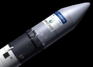
Engineers are gearing up for the launch of Europe’s next Copernicus satellite, the Sentinel-3B satellite, from Russia on April 25.
Sentinel-3B will join its twin, Sentinel-3A, in orbit. The pairing of the two identical satellites will provide the best coverage and data delivery for Europe’s Copernicus programme, which is reportedly the largest environmental monitoring programme in the world.
The satellites carry the same suite of cutting-edge instruments to measure oceans, land, ice and atmosphere.
Feeding a new generation of data products, the Sentinel-3 mission is at the heart of operational oceanography.
To put things in perspective, the Sentinels are a fleet of satellites designed to deliver a wealth of data and imagery that are central to the European Commission’s Copernicus programme.
This environmental monitoring programme enables analysts to view and manage our environment, understand and tackle the effects of climate change and safeguard everyday lives. Carrying a suite of cutting-edge instruments, Sentinel-3 will measure systematically Earth’s oceans, land, ice and atmosphere to monitor and understand large-scale global dynamics. It will provide essential information in near-real time for ocean and weather forecasting.
The mission is based on two identical satellites orbiting in constellation for optimum global coverage and data delivery. For example, with a swath width of 1270 km, the ocean and land colour instrument will provide global coverage every two days.
With a focus towards the earth’s oceans, Sentinel-3 measures the temperature, colour and height of the sea surface as well as the thickness of sea ice. These measurements will be used, for example, to monitor changes in sea level, marine pollution and biological productivity.
Over land, this mission will provide a bigger picture by monitoring wildfires, mapping the way land is used, provide indices of vegetation state and measure the height of rivers and lakes – complementing the high-resolution measurements of its sister mission Sentinel-2.
While Sentinel-3 will provide enhanced continuity of satellites such as Envisat and Spot, the sheer breadth of data from this new mission means that it is set to be the workhorse for Copernicus.
The mission is the result of close collaboration between ESA, the European Commission, Eumetsat, France’s CNES space agency, industry, service providers and data users.
As a prime example of Europe’s technological excellence, the two Sentinel-3 satellites have been designed and built by a consortium of around 100 companies under the leadership of Thales Alenia Space, France.
Once commissioned in orbit, ESA and Eumetsat will manage the mission jointly, where ESA processes land products and Eumetsat the marine products for application through the Copernicus services. Data are free of charge and open to users worldwide.
Sentinel-3A was launched on 16 February 2016. Sentinel-3B will be lofted into orbit on a Rockot launcher on 25 April at 17:57 GMT.


Add Comment